Eco Holiday Asia

Trekking trail to Everest Base Camp Nepal

Everest View Trek

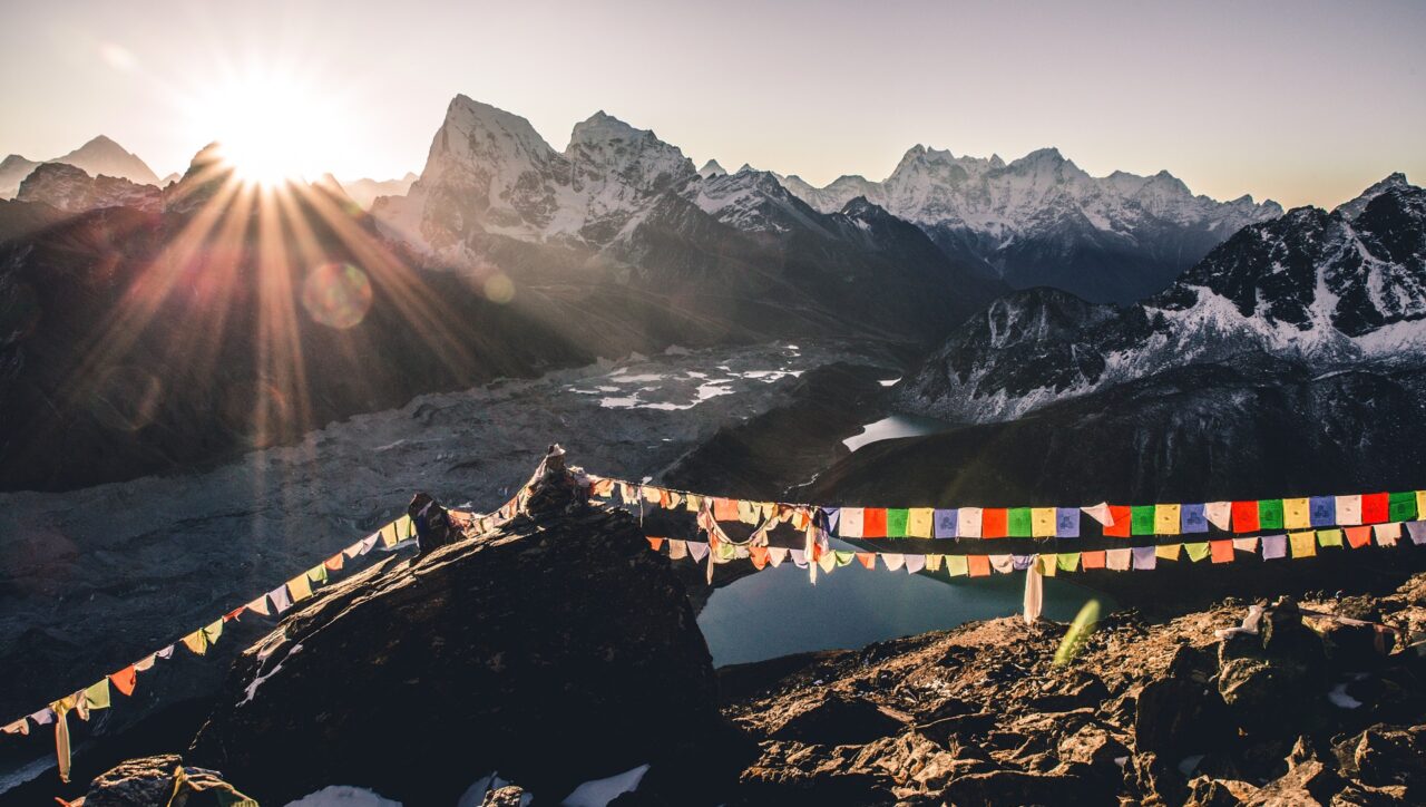
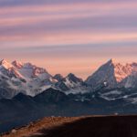
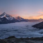
The Everest View Trek is a shorter alternative to the Everest Base Camp route, ideal for travellers who want to see the world’s highest peak without committing to a two-week expedition. Over 8–10 days, you fly to Lukla and walk through Sherpa villages to Namche Bazaar and the Everest View Hotel — one of the highest-placed hotels in the world — where Everest, Lhotse, and Ama Dablam fill the skyline.

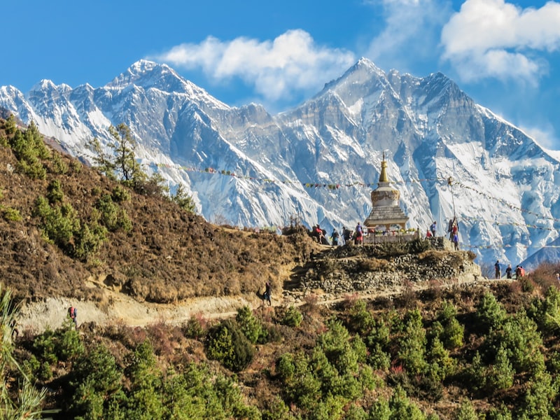
This trek follows the same trail as the classic EBC route for the first four days, passing through Phakding and ascending to Namche Bazaar (3,440m). From Namche, you hike to Syangboche and the famous Everest View Hotel at 3,880m before continuing to Khumjung village and Tengboche Monastery. The route stays below 4,000m, making it accessible to trekkers who prefer moderate altitude.

Why Choose the Everest View Trek?

Not everyone has two weeks for Everest Base Camp. This trek gives you genuine Himalayan mountain scenery, Sherpa cultural experiences, and views of Everest, Lhotse, Nuptse, and Ama Dablam — all in under ten days. Our guides are from the Khumbu region and share stories, monastery visits, and family connections along the way.
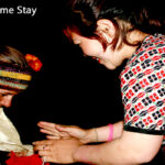
Community Impact

Your trek directly supports Sherpa families through homestay accommodation, local lodge bookings, and guide employment. We work with community cooperatives in Namche Bazaar and Khumjung to ensure trekking income stays in the Khumbu valley.

Itinerary Overview

  • Day 1: Arrive Kathmandu, transfer to hotel, trek briefing
  • Day 2: Fly Kathmandu to Lukla (2,860m), trek to Phakding (2,610m)
  • Day 3: Trek Phakding to Namche Bazaar (3,440m)
  • Day 4: Acclimatisation day in Namche — hike to Everest View Hotel (3,880m)
  • Day 5: Trek Namche to Khumjung village and Tengboche Monastery (3,867m)
  • Day 6: Explore Tengboche, afternoon views of Everest and Ama Dablam
  • Day 7: Trek Tengboche to Namche Bazaar
  • Day 8: Trek Namche to Lukla
  • Day 9: Fly Lukla to Kathmandu

Best Season

October–November (clear skies, comfortable temperatures, festival season) and March–May (warmer, rhododendron blooms). December–February is cold but clear. Monsoon (June–August) is not recommended for the Khumbu region.

Permits & Access

Sagarmatha National Park entry permit (NPR 3,000) and Khumbu Pasang Lhamu Rural Municipality permit required. TIMS card is no longer required in the Khumbu region as of 2026. We handle all permit arrangements.

Responsible Travel

We follow KEEP guidelines for porter welfare, use local guides from the Khumbu region, and prioritise community lodges. Your trek fees support local families, monastery maintenance funds, and community trail upkeep projects.

Frequently Asked Questions

How difficult is the Everest View Trek?

Moderate. The highest point is 3,880m (Everest View Hotel). You need to be comfortable walking 4–6 hours per day on mountain trails, but no technical climbing is involved.

Can I see Everest on this trek?

Yes. Clear views of Everest (8,849m), Lhotse, Nuptse, and Ama Dablam from Namche Bazaar, Syangboche, and Tengboche. The Everest View Hotel was specifically built at a spot with an unobstructed Everest panorama.

Is this trek suitable for beginners?

Yes, for reasonably fit beginners. The altitude is moderate and the trail is well-established. We include acclimatisation days and our guides monitor your health throughout.

Gokyo Ri

Gokyo Lakes Trek

The Gokyo Lakes Trek is a stunning alternative to the Everest Base Camp route, leading through the quieter western side of the Khumbu valley to a chain of turquoise glacial lakes at the foot of Cho Oyu (8,188m). The trek culminates at Gokyo Ri (5,357m), where the sunrise panorama includes four of the world’s six highest peaks — Everest, Lhotse, Makalu, and Cho Oyu — spread across the horizon in a single sweeping view.

Unlike the crowded EBC trail, the Gokyo route sees far fewer trekkers, especially past Dole. You walk alongside the Ngozumpa Glacier — the longest in the Himalayas — through high-altitude Sherpa settlements where families have lived for generations. Our guides are from the Khumbu region and share their knowledge of the landscape, Buddhist traditions, and mountain ecology throughout the trek.

Community Impact

Your trek supports Sherpa families who run teahouses in Namche, Dole, Machhermo, and Gokyo. Porter wages, guide employment, and lodge fees stay in the Khumbu valley. By choosing the Gokyo route over the busier EBC trail, you help distribute tourism income to communities that receive fewer visitors.

Itinerary Overview

  • Day 1: Arrive Kathmandu, hotel transfer, trek briefing
  • Day 2: Fly to Lukla (2,860m), trek to Phakding (2,610m)
  • Day 3: Trek to Namche Bazaar (3,440m)
  • Day 4: Acclimatisation day in Namche — hike to Everest View Hotel
  • Day 5: Trek to Phortse Tenga (3,680m)
  • Day 6: Trek to Dole (4,110m)
  • Day 7: Trek to Machhermo (4,470m)
  • Day 8: Trek to Gokyo (4,790m)
  • Day 9: Gokyo Ri summit (5,357m), explore Gokyo Lakes
  • Day 10: Trek to Dole (4,110m)
  • Day 11: Trek to Namche Bazaar (3,440m)
  • Day 12: Trek to Lukla (2,860m)
  • Day 13: Fly Lukla to Kathmandu
  • Day 14: Departure day

Best Season

October-November (clear skies, stable weather) and March-May (warmer, rhododendron season). Winter is possible but very cold above 4,000m.

Permits

Sagarmatha National Park entry permit and Khumbu Rural Municipality permit required. We arrange all permits before your trek.

Frequently Asked Questions

How difficult is the Gokyo Lakes Trek?

Moderate to challenging. The highest point is Gokyo Ri at 5,357m. You need good fitness for 5-7 hours of walking per day at altitude. No technical climbing is involved.

Is Gokyo Ri harder than Everest Base Camp?

The altitude is similar (Gokyo Ri 5,357m vs EBC 5,364m). Gokyo Ri involves a steep morning ascent from 4,790m but the overall trek has fewer long walking days. Both require proper acclimatisation.

Can I combine Gokyo Lakes with Everest Base Camp?

Yes. The Cho La Pass connects Gokyo to the EBC route via Dzongla. This adds 3-4 days and requires experience with high passes. Ask us about the combined itinerary.

Annapurna mountain range trekking trail in Nepal

Annapurna Base Camp Trek

The Annapurna Base Camp Trek takes you into the heart of the Annapurna Sanctuary — a natural amphitheatre surrounded by peaks above 7,000m on all sides. Over 12 days, you walk through subtropical forests, rhododendron groves, terraced farmland, and Gurung hill villages before ascending into the alpine zone and arriving at base camp (4,130m), where Annapurna I, Machhapuchhre, Hiunchuli, and Gangapurna tower overhead.

This is one of Nepal’s most popular treks for good reason: the mountain scenery is extraordinary, the trail is well-established, and the cultural richness of the Gurung and Magar communities along the route adds depth that pure mountain treks often lack. Our guides are from the Annapurna region and know both the trails and the families who run the lodges you stay in.

Community Impact

The ABC trail passes through villages where families have converted their homes into teahouses over decades. Your lodge fees, meals, and guide wages stay in these communities. In Ghandruk and Chhomrong, community tourism cooperatives manage visitor flow and reinvest in local schools and trail maintenance.

Itinerary Overview

  • Day 1: Arrive Kathmandu, transfer to hotel, trek briefing
  • Day 2: Drive Kathmandu to Pokhara (tourist bus or flight)
  • Day 3: Drive to Nayapul, trek to Tikhedhunga (1,540m)
  • Day 4: Trek to Ghorepani (2,860m)
  • Day 5: Sunrise at Poon Hill (3,210m), trek to Tadapani (2,630m)
  • Day 6: Trek to Chhomrong (2,170m)
  • Day 7: Trek to Dovan (2,600m)
  • Day 8: Trek to Deurali (3,230m)
  • Day 9: Trek to Annapurna Base Camp (4,130m) via Machhapuchhre Base Camp
  • Day 10: Sunrise at ABC, descend to Bamboo (2,310m)
  • Day 11: Trek to Nayapul, drive to Pokhara
  • Day 12: Fly or drive Pokhara to Kathmandu, departure

Best Season

October-November (clear skies, cool temperatures) and March-May (warmer, rhododendrons in bloom). The Sanctuary can receive heavy snow in winter.

Permits

Annapurna Conservation Area Permit (ACAP) and TIMS card required. We handle all permits.

Frequently Asked Questions

How difficult is the Annapurna Base Camp Trek?

Moderate. The highest point is 4,130m, well below the altitude of Everest-region treks. You walk 5-7 hours per day on well-maintained trails. Good general fitness is needed but no technical skills.

Can I do ABC without Poon Hill?

Yes. A direct route via Chhomrong skips Ghorepani and Poon Hill, reducing the trek by 2 days. However, Poon Hill offers one of the best sunrise views in Nepal and is worth the detour.

Is the Annapurna Base Camp Trek suitable for beginners?

Yes, for fit beginners. The altitude is moderate, the trail is well-marked, and teahouse accommodation is comfortable. We include acclimatisation time and our guides pace the trek to suit your fitness.

Ghorepani Poon Hill Trekking - Eco Holiday Asia

Ghorepani Poon Hill Trek

The Ghorepani Poon Hill Trek is Nepal’s finest short trek — a 7-day journey through Gurung hill villages, rhododendron forests, and terraced farmland to one of the most celebrated viewpoints in the Himalayas. From Poon Hill (3,210m) at sunrise, you see Dhaulagiri (8,167m), the entire Annapurna massif, Machhapuchhre (Fishtail Mountain), and snow-capped peaks stretching across the horizon in every direction.

This is the trek we recommend most often to first-time visitors. The altitude stays moderate, the trails are well-established, the teahouses are comfortable, and the scenery is world-class. You walk through living communities — Gurung and Magar villages where farming, weaving, and traditional life continue alongside trekking tourism. Our guides are from these communities and introduce you to families, food, and stories along the way.

Community Impact

Ghandruk and Ghorepani are model examples of community-managed trekking tourism. Local cooperatives manage lodges, maintain trails, and distribute tourism income across the village. Your stay directly supports these systems — from the family cooking your dal bhat to the porter carrying your bag.

Itinerary Overview

  • Day 1: Drive Kathmandu to Pokhara (6-7 hours or 25-minute flight)
  • Day 2: Drive to Nayapul, trek to Tikhedhunga (1,540m)
  • Day 3: Trek to Ghorepani (2,860m) through rhododendron forest
  • Day 4: Sunrise at Poon Hill (3,210m), trek to Tadapani (2,630m)
  • Day 5: Trek to Ghandruk (1,940m), explore the Gurung village
  • Day 6: Trek to Nayapul, drive to Pokhara
  • Day 7: Fly or drive to Kathmandu, departure

Best Season

October-November and March-May. Spring (March-April) is especially beautiful when the rhododendron forests are in full bloom.

Frequently Asked Questions

Is the Poon Hill Trek suitable for beginners?

Yes. This is one of the most accessible treks in Nepal. The altitude is moderate (max 3,210m), trails are well-maintained, and you walk 4-6 hours per day. Good general fitness is sufficient.

Can I do this trek with children?

Children aged 10 and above who enjoy hiking can do this trek comfortably. We adjust the pace and provide additional porter support for families.

What is the best time for rhododendrons?

Late March to mid-April. The forests between Tikhedhunga and Ghorepani are spectacular during bloom season.

Mardi Himal Trekking - Eco Holiday Asia

Mardi Himal Trek

The Mardi Himal Trek follows a dramatic ridgeline directly toward the face of Machhapuchhre (Fishtail Mountain) — one of Nepal’s most sacred and visually striking peaks. This relatively new route opened to trekkers in recent years and remains far less crowded than the nearby Annapurna Base Camp or Poon Hill trails. You walk through forests of oak and rhododendron, emerge onto open ridgelines above the clouds, and arrive at Mardi Himal Base Camp (4,500m) with Machhapuchhre and Annapurna South filling the sky ahead.

What makes Mardi Himal special is the feeling of walking on the roof of the world with very few other people around. The lodges are small and family-run, the trail passes through genuine rural Nepal, and the views — especially from High Camp at sunset — are among the most dramatic in the Annapurna region. Our guides know this trail intimately and can time the trek so you catch the best light and weather windows.

Community Impact

The Mardi Himal route is newer than classic Annapurna trails, meaning the communities along it are still building their tourism livelihoods. Your visit supports small lodge operators, local guides, and families in villages like Lwang and Siding who are just beginning to benefit from trekking tourism.

Itinerary Overview

  • Day 1: Arrive Kathmandu, transfer to hotel
  • Day 2: Drive or fly to Pokhara
  • Day 3: Drive to Kande, trek to Pothana/Forest Camp (2,490m)
  • Day 4: Trek through forest to Low Camp (2,990m)
  • Day 5: Trek to High Camp (3,580m), ridge walking above the clouds
  • Day 6: Trek to Mardi Himal Base Camp (4,500m), return to High Camp
  • Day 7: Descend to Siding village, drive to Pokhara
  • Day 8: Return to Kathmandu

Frequently Asked Questions

Is Mardi Himal Trek difficult?

Moderate. The trail involves some steep sections and the highest point is 4,500m. You walk 5-6 hours per day. Suitable for fit trekkers with some hiking experience.

How does Mardi Himal compare to Poon Hill?

Mardi Himal is higher (4,500m vs 3,210m), wilder, and less crowded. Poon Hill is easier and more established. Both have outstanding views. Choose Mardi for adventure and solitude, Poon Hill for accessibility.

Annapurna mountain range trekking trail in Nepal

Khopra Danda Trek

The Khopra Danda Trek is one of Nepal’s best community-managed trekking routes — a 9-day journey to a high ridge with commanding views of Dhaulagiri (8,167m), Annapurna South, Nilgiri, and the entire western Annapurna range. The community lodge at Khopra Ridge (3,660m) is entirely owned and operated by local villagers, with profits reinvested in schools, health posts, and trail maintenance. This is community-based tourism at its most genuine.

The optional side trip to Khayer Lake (4,500m), a sacred lake below Annapurna South, adds an extra day of high-altitude walking through alpine meadows where few trekkers venture. The route connects with the Ghorepani-Poon Hill trail, so you can combine both for a comprehensive Annapurna experience without repeating any ground.

Community Impact

Khopra Danda is a flagship community tourism project developed with support from the Annapurna Conservation Area Project (ACAP). The lodge at Khopra Ridge was built by villagers from Swanta and nearby settlements, and all revenue stays in the community. Your trek directly funds local livelihoods, trail workers, and community development projects.

Itinerary Overview

  • Day 1: Drive or fly Kathmandu to Pokhara
  • Day 2: Drive to Nayapul, trek to Tikhedhunga (1,540m)
  • Day 3: Trek to Ghorepani (2,860m)
  • Day 4: Sunrise at Poon Hill, trek to Swanta (2,200m)
  • Day 5: Trek to Khopra Ridge Community Lodge (3,660m)
  • Day 6: Side trip to Khayer Lake (4,500m) and return to Khopra
  • Day 7: Descend to Tatopani or Ghara (1,890m)
  • Day 8: Drive to Pokhara
  • Day 9: Return to Kathmandu

Frequently Asked Questions

Is the Khopra Danda Trek difficult?

Moderate. The highest point is Khayer Lake at 4,500m (optional). The main ridge at 3,660m is comfortable for fit trekkers. Some steep ascent sections between Swanta and Khopra.

What makes this a community trek?

The lodges, guides, and support staff are all from local villages. Profits go to community funds, not private operators. You eat locally grown food, sleep in community-built lodges, and walk with guides who grew up in these hills.

Langtang Valley Trek

Langtang Valley Trek

The Langtang Valley Trek follows the Langtang Khola through one of Nepal’s most beautiful Himalayan valleys — and one of its most resilient. The valley was devastated by avalanches during the 2015 earthquake, and the Tamang communities here rebuilt their villages and lodges with extraordinary determination. Today, trekking in Langtang directly supports families who have poured everything into their recovery.

The trail winds through subtropical forests, bamboo groves, and yak pastures before opening into the broad upper valley below Langtang Lirung (7,227m). At Kyanjin Gompa, you visit an ancient monastery and a cheese factory that produces yak cheese using traditional Swiss-taught methods. An optional climb to Tserko Ri (4,984m) rewards with panoramic views across the entire valley and into Tibet.

Community Impact

Every lodge in the Langtang Valley is family-run by Tamang villagers who rebuilt after the earthquake. Your visit is not just tourism — it is a direct contribution to the recovery of communities that lost homes, family members, and livelihoods. Guides from the valley share the story of their villages with pride and gratitude.

Itinerary Overview

  • Day 1: Drive Kathmandu to Syabrubesi (1,550m) — 7-8 hours through hill country
  • Day 2: Trek to Lama Hotel (2,380m) through oak and rhododendron forest
  • Day 3: Trek to Langtang village (3,430m)
  • Day 4: Trek to Kyanjin Gompa (3,870m)
  • Day 5: Explore Kyanjin — optional hike to Tserko Ri (4,984m) or Kyanjin Ri
  • Day 6: Trek down to Lama Hotel (2,380m)
  • Day 7: Trek to Syabrubesi (1,550m)
  • Day 8: Drive to Kathmandu
  • Days 9-10: Kathmandu and departure

Frequently Asked Questions

Is the Langtang Valley Trek difficult?

Moderate. Maximum altitude is 3,870m (Kyanjin Gompa) or 4,984m if you climb Tserko Ri. Trails are well-established. Walking 5-6 hours per day. Suitable for fit beginners.

Do I need to fly to start this trek?

No. Langtang starts from Syabrubesi, reached by road from Kathmandu in 7-8 hours. This makes it one of the most accessible major treks in Nepal.

Explore More

Related experiences:

Plan your Nepal trip: Trekking in Nepal | Best Places to Visit

Ready to book? Contact Eco Holiday Asia or message us on WhatsApp. We reply within 24 hours.

Langtang Valley Trek

Gosaikunda Trek

The Gosaikunda Trek leads to one of Nepal’s holiest high-altitude lakes — Gosaikunda (4,380m), a glacial lake sacred to both Hindus and Buddhists. Legend holds that Lord Shiva created the lake by striking the mountain with his trident. During the Janai Purnima festival in August, thousands of pilgrims trek here to bathe in the sacred waters. Outside festival season, the trail is quiet and the mountain scenery is stunning.

Starting from Dhunche (reached by road from Kathmandu), the route climbs through dense rhododendron and oak forests before emerging into alpine meadows dotted with stone shelters. The lake itself sits in a dramatic cirque below Gosaikunda Peak, with the Langtang and Ganesh Himal ranges visible on clear days. This is an excellent shorter trek for those wanting a meaningful mountain experience without committing to a two-week expedition.

Itinerary Overview

  • Day 1: Drive Kathmandu to Dhunche (1,960m)
  • Day 2: Trek to Sing Gompa (3,330m)
  • Day 3: Trek to Gosaikunda Lake (4,380m)
  • Day 4: Explore the sacred lakes, optional hike to Laurebina viewpoint
  • Day 5: Descend to Sing Gompa
  • Day 6: Trek to Dhunche
  • Day 7: Drive to Kathmandu
  • Day 8: Departure

Frequently Asked Questions

Is Gosaikunda difficult?

Moderate. The highest point is 4,380m. The ascent from Sing Gompa to Gosaikunda is steep but the trail is clear. Walking 5-6 hours per day.

Can I combine Gosaikunda with Langtang?

Yes. A popular option crosses Laurebina La (4,610m) to connect with the Helambu trail, or you can do Langtang Valley first and add Gosaikunda as an extension. Ask us for the combined itinerary.

Explore More

Related experiences:

Plan your Nepal trip: Trekking in Nepal | Best Places to Visit

Ready to book? Contact Eco Holiday Asia or message us on WhatsApp. We reply within 24 hours.

Jomsom Muktinath Eco Trekking with Eco Holiday Asia

Jomsom Muktinath Trek

The Jomsom Muktinath Trek follows the Kali Gandaki river through the deepest gorge in the world, passing between the massive flanks of Dhaulagiri (8,167m) and Annapurna I (8,091m). The destination is Muktinath Temple (3,800m), one of Nepal’s most important pilgrimage sites — sacred to both Hindus and Buddhists, where natural gas flames burn eternally alongside a spring-fed water source. Pilgrims from across South Asia come here believing the site grants salvation.

Beyond the spiritual significance, this trek passes through the heart of Thakali country — a culturally distinct region famous across Nepal for its cuisine, hospitality, and entrepreneurial spirit. You eat the best dal bhat on any Nepal trek, sleep in well-maintained Thakali lodges, and walk through apple orchards that produce the brandy and cider that have made Marpha village famous.

Community Impact

The Thakali people have been running lodges and restaurants along this route for decades. Tourism is woven into their culture. Your stay supports families who take genuine pride in their hospitality, along with temple maintenance funds and community orchards.

Itinerary Overview

  • Day 1: Arrive Kathmandu
  • Day 2: Drive or fly to Pokhara
  • Day 3: Fly Pokhara to Jomsom (2,720m), trek to Kagbeni (2,810m)
  • Day 4: Trek to Muktinath Temple (3,800m)
  • Day 5: Explore Muktinath, return to Kagbeni
  • Day 6: Trek to Marpha (2,670m), visit apple orchards
  • Day 7: Trek to Kalopani (2,530m), hot springs
  • Day 8: Trek to Tatopani (1,190m) or drive to Pokhara
  • Day 9: Drive or fly to Kathmandu
  • Day 10: Departure

Frequently Asked Questions

Is this trek suitable for pilgrims?

Yes. Many travellers combine trekking with spiritual pilgrimage. The trail to Muktinath is well-established and can be adjusted for older pilgrims or those with moderate fitness.

Do I need a restricted area permit?

No. Jomsom and Muktinath are in Lower Mustang, which requires only the Annapurna Conservation Area Permit and TIMS card. No restricted area permit needed.

Explore More

Related experiences:

Plan your Nepal trip: Trekking in Nepal | Best Places to Visit

Ready to book? Contact Eco Holiday Asia or message us on WhatsApp. We reply within 24 hours.

Arun Valley Trek

Arun Valley Trek

The Arun Valley Trek follows one of Nepal’s great rivers through a warm, subtropical valley in the far east of the country — a region that most trekkers never reach. The Arun River cuts through the Himalayan range from Tibet, creating a deep valley with extraordinary biodiversity, from tropical lowland forests to alpine meadows in the space of a few days’ walk.

The trail passes through villages of the Rai, Limbu, and Sherpa communities — the indigenous peoples of eastern Nepal, each with distinct languages, customs, and traditions that differ markedly from the better-known cultures of the Annapurna and Everest regions. This is a low-altitude, culturally rich trek that works well in winter and serves as a standalone experience or as an approach route for the Makalu Base Camp trek.

Community Impact

Eastern Nepal’s Arun Valley receives very few tourists. Your trek supports Rai and Limbu families who offer homestay accommodation and guide services. Village visits and meals at local homes provide direct economic benefit to communities that are navigating the changes brought by hydropower development in the valley.

Frequently Asked Questions

Is this a low-altitude trek?

Mostly. The Arun Valley floor ranges from 500m to 2,500m. Optional viewpoint hikes reach higher. This makes it one of the few Nepal treks comfortable in winter months (December-February).

Explore More

Related experiences:

Plan your Nepal trip: Trekking in Nepal | Best Places to Visit

Ready to book? Contact Eco Holiday Asia or message us on WhatsApp. We reply within 24 hours.